
Entries by Monsoon Martin (572)
After the storm
Hi there.
So the storm shifted east, and I could explain why using meteorological jargon, but you don't care. You may not even be reading this anymore. I can't blame you.
Just one more thing: wanted to give my school closing meter for Thursday 3/8.
For Berks County schools:
Chance of delay Thursday, 31.57%
Chance of cancellation Thursday, 11.34%
The Sunday-Monday coastal storm is trending as a miss for us (out to sea).
Thundersnow in NJ! (Clip below.)
Stay tuned for updates!
Updated forecast for Wednesday 3/7/18
 Right to it.
First, I will present the forecast for the Reading/Berks area. (Also applies to Lehigh Valley.)
Rain showers begin by 5-6pm on Tuesday. Changeover to all snow by 11-12pm. The most intense/heavy snowfall will be Wednesday from about noon-5pm. Tapers by 9-11pm. Could even be some stray flurries and snow showers on Thursday morning.
Accumulation: 8-12 inches. Maybe even a bit more in isolated areas.
My concern is that areas affected by power outages last Friday (some of whom still don't have it back on) may be impacted more severely by this storm. If you imagine a Venn diagram with that encompasses those slammed by last Friday's storm and those that are in the bull's eye for this storm, hunker down, guys.
School impacts:
Chance of school delay on Wednesday, 7.82% (wouldn't make much sense)
Chance of early dismissal Wednesday, 96.23% (if there is school)
Chance of cancellation Wednesday, 79.27%
Chance of delay on Thursday, 61.55%
Chance of cancellation on Thursday, 43.11%
Forecast for areas other than Berks:
NYC and north Jersey (including Nutley), a bit more mixed precipitation, but still impressive totals of 7-9 inches. Snow doesn't get going til overnight Tuesday-Wednesday.
Lititz and Lancaster are right on the edge of this system. Same with Kirkwood and Gap. Just snow showers with 2-3 inches of accumulation.
Harrisburg and Shippensburg, definite outliers. Scattered rain and snow showers will give way to more frequent periods of snow on Wednesday afternoon. Only about 1-2 inches.
State College, you get snow showers on and off between Tuesday night and Wednesday night, but nothing that will accumulate or be problematic.
Philadelphia and immediate suburbs, 4-6 inches. (Isolated areas and higher-elevation areas get a little more.) A bit more mixing. Kinda windy, but nothing approaching what we had last Friday.
Princeton, NJ, pretty much the same accumulation as Berks and Lehigh. About 8-12 inches. Kinda windy.
Toms River, NJ, a wintry mix accumulating 2-3 inches. Unlike other places, the Jersey Shore and South Jersey will be impacted by sleet. So that will make things treacherous.
As always, please send your snow reports and travel impacts to me via email.
Stay tuned for updates.
Forecast: Wednesday, March 7, 2018
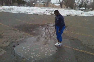 Right before he jumps (into what he assumes is a shallow puddle, to win a $1 bet), he says, "I do it for the kids."Alright, so there's more.
Monday will be quiet: mostly sunny with a high in the mid 40s.
Tuesday will be similar, but we'll see increasing clouds throughout the morning. On-and-off rain showers will begin by 2-3pm.
Rain will become steadier by about 8pm. Expect rain to begin mixing with wet snow by 10pm, and this mix will continue overnight.
I think it becomes all snow by 3-5am. It'll snow til Wednesday evening - maybe 6-8pm.
Amounts and precipitation type are especially tricky this time of year, given the sun angle, surface temperatures, and all the moving meteorological parts in this storm.
On Monday, I'm going to give more nuanced forecasts (like, broken down by area/specific location). So please let me know via email if you'd like me to include your area in my next forecast.
But here is what I expect for Berks:
Accumulation, 4-6 inches.
I don't see widespread outages and downed limbs/power lines with this storm. Not a whole lot of crazy wind with this one.
Chance of delay Wednesday, 65.44%
Chance of cancellation Wednesday, 41.66%
Stay tuned for updates!
Update on the Coastal Storm
Hi!
The forecast models have shifted a bit, so I need to adjust my forecast accordingly.
First, the winds are going to be more intense than I said in the previous forecast. Sustained winds above 30mph by Friday afternoon, with gusts as high as 60mph! That's tropical storm strength, tiptoeing toward category 1 hurricane strength.
So you'll want to bring in your garbage cans, bins, garden accoutrements -- anything that can become a projectile in high winds.
 The second change is the start time for the snowfall - heavy, wet snow will start mixing in around 1 or 2pm. Accumulations will be negligible around here (an inch or two at most) and most paved surfaces will just be wet. BUT - and in the immortal words of P. W. Herman, "Everyone I know has a big 'but'" - the snow could be heavy at times during Friday afternoon, and when this happens, roadways can become covered and slippery quite rapidly.
Add the high winds and we're talking about near-blizzard conditions.
I would expect to see some power outages from this beast.
I am also adding a school closing meter for this storm:
Chance of cancellation Friday, 2.31%
Chance of early dismissal Friday, 27.92%
Stay tuned for updates and be sure to report road conditions, outages, and whatnot to me on the email.
Coastal Storm to Kick Off March
Thursday 3/1 starts with some sun, but clouds roll in rapidly. Rain and drizzle start by early afternoon. Heaviest rain is Thursday evening and overnight. Rain and showers continue through Friday morning and even to early Friday evening.
Temperatures: 50 Thursday afternoon, mid 40s overnight, and around 40 steadily on Friday. When temperatures dip into the mid 30s -- this happens around 10-11pm Friday night -- precipitation will just be winding up. There's the possibility of up to 1/2 inch of wet snow on the "back end" of the storm. But given the relatively mild surfaces temperatures recently and the light/scattered nature of these showers, the snow will just melt on paved surfaces and is nothing at all to worry about.
Speaking of snow: if this system were snow, using a 10:1 snow ratio, and considering most of us will be getting an inch and a half or more of rain, we are dodging a 15-20 inch snow dump here.
Watch out for flooding, especially in areas that already have swollen rivers and creeks.
The wind: picks up overnight. 10mph 6 or 7am Friday. Sustained winds over 20mph by noon Friday. Gusts over 40mph by late Friday afternoon and evening. Winds don't die down until Saturday afternoon and evening.

So is this it?
I'm looking at 3/10 and 3/14-15 for wintry weather potential. But these are outside chances.
Stay tuned for updates!
 Monsoon Martin
|
Monsoon Martin
|
 Post a Comment
|
Post a Comment
|  Email
|
Email
|  Print
Print
