
Entries by Monsoon Martin (572)
Forecast for January 8-9 precipitation event
 The really good news I have, weather-wise, is that this arctic freeze is coming to an end: temperatures will climb to near freezing (32) on Monday 1/8, then upper 30s on Tuesday 1/9. Yes - pipes all over the area will thaw out, and I desperately hope they do so peacefully.
So. Cold tonight (Sunday 1/7) with a low of 9.
On Monday, we'll see temperatures rise to 28 or 29, so the concerns we originally had about mixed precipitation / icing will not be an issue. We'll see some periods of snow between about 1 and 6pm. It will accumulate only about 1/2 inch to an inch, but the snowfall could create some reduced visibility and slippery spots, so use caution during the PM commute.
I don't see any appreciable likelihood for this snow event to cause early dismissals Monday or delays Tuesday. #sorryteachersandstudents
Tuesday 1/9 will turn out mostly sunny with a high near 40, which will feel positively balmy compared with the past 10 days or so.
Wednesday 1/10 will be in the 30s and will feature times of clouds and sun.
Thursday 1/11 will bring precipitation, but temperatures will stay in the low to mid 40s, so expect just rain showers and drizzle (rather than anything frozen or wintrily problematic).
 Yes, it's a word.
That rainy-drizzly dankness continues on Friday 1/12, when temperatures will mostly by in the mid to upper 40s, but may rise into the low 50s (!).
And then rainy and cooler for at least the first half of Saturday 1/13 with a high of 42 and a low in the upper 20s.
Thereafter: More like seasonal averages for the period from Sunday 1/14 through Wednesday 1/17, with highs in the 30s and lows in the upper teens to low 20s. And then expect temperatures to get milder after that.
The next chance of snow that I see (after Monday 1/8, of course)? Wednesday 1/24 - Thursday 1/25.

 Post a Comment
 Email
Email Print
PrintThe Jawn's Arctic Aftermath
Alright, so the storm behaved pretty much as I expected, at least around here. (The coastal flooding in Boston is unreal.)
Now the deep freeze.
The high on Friday 1/5/18 will be 14. That will feel like -10, courtesy of the wind. The low will be 1. (And that will feel like -23.)
Due to blowing snow and dangerously low wind chills, I call for Friday:
96.7% delays
83.2% cancellations
Saturday 1/6 will be even colder: High 12 (wind chill of -8), low of -2 (actual temperature; wind chill of -6). It'll be colder, but a bit less frigid because of diminished winds.
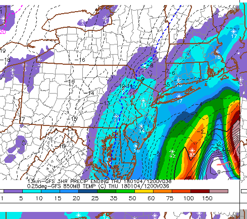
Jan. 4th Coastal Jawn Update (5:45pm Wednesday)
The key with this storm is how quickly it strengthens and the exact track it will take. That's so vital for us because we (in Berks County) are in that "cutoff" range: areas to the south and east will get 1-3 inches, but areas in the "cutoff" range will barely see snow.
On a personal (and meteorologically nerdy) note, this is an exciting storm to watch, as it features a dramatic drop in barometric pressure producing something called bombogenesis, which is a badass term coined (made up) by meteorologists in the 1940s, but used more widely in recent years. Properly speaking, it's an explosive cyclogenesis, which literally comes from the Greek word for circle or coil + the Greek word for origin or creation.
Anywho. Forecast update.
Still looking at the Boston area and Maine as the bull's eye for this storm, but I'll also add coastal New Hampshire, coastal Connecticut, and pretty much all of Rhode Island. Those areas will get 18 to 24 inches of snow, with isolated areas exceeding two feet.
Closer to home: extreme south Jersey, coastal Delaware, and coastal areas in Maryland will pick up in the 12 to 16 inch range.
Interior New Jersey, the rest of Delaware, Philly, and the bulk of NYC will be in the range of 4 to 6 inches.
Eastern Berks County, Lehigh Valley, Eastern Lancaster County, and the bulk of Chester County will pick up 2 to 4 inches.
Central Berks (including the city of Reading), central and western Lancaster, out into York County - these are the cutoff areas. I see a coating to an inch for this area.
School closings: several schools (Reading, Exeter, Boone) have already called delays for tomorrow - I think this is due to the extreme low temperatures and winds expected. I expect more to follow suit, but in this area, I don't see a lot of cancellations. Delay would be a great idea for Friday as well. (On Friday morning at 7am, it's gonna feel like -15.)
Oh, and just for Adam and Maggie Exas (and even little Ainsley) - Thursday will be sunny and clear with a high of 40 and low of 20. (Wind chills in the teens, so that's pretty low for you delicate Savannahians!) It will be in the 50s on Sunday and the 60s on Monday, so there's that to look forward to!!
So there you have it.
 Monsoon Martin
Update: I am thinking we'll see a lot of delays and cancellations in Philly as well as Bucks, Montgomery, Chester, Lehigh, and Berks Counties. The amounts are not the issue - generally 2 to 4 inches. It's the timing that will necessitate delays and cancellations: about 4-11am. And finally, it's the wind: 15-20mph with gusts 25-30, especially as the storm winds up. The wind will reduce visibility to dangerous levels.

This January 4th Coastal Jawn
Right now, it's looking like the coastal storm's track will have the following impacts:
NJ shore, 3-6 inches
Philadelphia, Lehigh Valley, interior NJ, 1-3 inches
Berks, Lancaster, a few snow showers, accumulating a coating to an inch.
The storm will be a direct hit for the Boston area and for Maine, where it will dump 18-24 inches of snow and produce blizzard conditions.
So here's my full forecast for the next five days in Berks:
Tuesday 1/2: sunny and breezy with a high of 22 (wind chill 12) and a low of 8 (wind chill 4).
Wednesday 1/3: partly sunny and still cold, but with calmer wind. High 29 (w.c. 25), low 18 (w.c. 16).
Thursday 1/4: overcast, cold. A few overnight snow showers or flurries (Wed into Thu). High 22, low 6.
Friday 1/5: COME ON. It's going to be even colder. Very windy. High of 13 (w.c. -7), low of 2 (w.c. -15).
Saturday 1/6: Just rudely cold. High of 12 (w.c. -4), low of 1 (w.c. -7).
Beyond: A bit less frigid on Sunday 1/7 and then it might actually get above freezing on Monday 1/8! There's a good chance for some snow and ice on that day, though.
Stay tuned for updates!
Could it be a White Christmas?
A wintry mix tonight (Sunday 12/24). Wet snow and rain not really getting going until after 9 or 10pm. Maybe an inch or two of slushy accumulation, ending before daybreak on Monday 12/25. There might be some slippery spots overnight, especially on bridges/overpasses. But unless you're out late on Christmas eve, or you are Santa Claus, you will not experience any travel issues with this little event.

Christmas day will be colder (high 35) and very windy. (Sustained winds 20-30mph with gusts 40-50mph!) Good day to hunker down and spend time with the fam.
Tuesday 12/26 will be sunny and cold: high 29, low 17. Still kinda breezy.
Wednesday 12/27 and Thursday 12/28 will be sunny and a bit colder: highs in the mid 20s, lows in the low teens.
Friday 12/29 is definitely going to be cloudy and cold (high in the mid 20s), but right now there's about a 50/50 shot of having a snow event.
Another potential snow event will be around on Saturday 12/30 (late afternoon, evening, and overnight).
Stay tuned for updates on the 12/29 and 12/30 events.
Then it's just continued sunny and cold on 12/31 and 1/1. My fervent annual hope that snow/ice/rain will thwart the Mummers Parade by dampening its inimitable melange of sequins and racism - well, that wish looks as though it will be unfulfilled this year - but at least it will be cold (20s most of the day).

Enjoy the times of the holiday. Family. Hearth, or whatever.
Monsoon
P.S. Remember to keep submitting questions about weather or not-weather that may well be answered in a forthcoming post!
