
Jan. 4th Coastal Jawn Update (5:45pm Wednesday)
The key with this storm is how quickly it strengthens and the exact track it will take. That's so vital for us because we (in Berks County) are in that "cutoff" range: areas to the south and east will get 1-3 inches, but areas in the "cutoff" range will barely see snow.
On a personal (and meteorologically nerdy) note, this is an exciting storm to watch, as it features a dramatic drop in barometric pressure producing something called bombogenesis, which is a badass term coined (made up) by meteorologists in the 1940s, but used more widely in recent years. Properly speaking, it's an explosive cyclogenesis, which literally comes from the Greek word for circle or coil + the Greek word for origin or creation.
Anywho. Forecast update.
Still looking at the Boston area and Maine as the bull's eye for this storm, but I'll also add coastal New Hampshire, coastal Connecticut, and pretty much all of Rhode Island. Those areas will get 18 to 24 inches of snow, with isolated areas exceeding two feet.
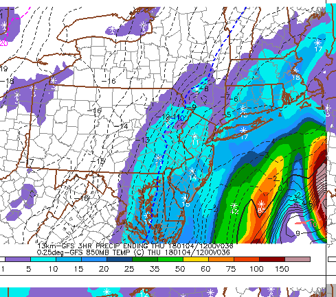
Closer to home: extreme south Jersey, coastal Delaware, and coastal areas in Maryland will pick up in the 12 to 16 inch range.
Interior New Jersey, the rest of Delaware, Philly, and the bulk of NYC will be in the range of 4 to 6 inches.
Eastern Berks County, Lehigh Valley, Eastern Lancaster County, and the bulk of Chester County will pick up 2 to 4 inches.
Central Berks (including the city of Reading), central and western Lancaster, out into York County - these are the cutoff areas. I see a coating to an inch for this area.
School closings: several schools (Reading, Exeter, Boone) have already called delays for tomorrow - I think this is due to the extreme low temperatures and winds expected. I expect more to follow suit, but in this area, I don't see a lot of cancellations. Delay would be a great idea for Friday as well. (On Friday morning at 7am, it's gonna feel like -15.)
Oh, and just for Adam and Maggie Exas (and even little Ainsley) - Thursday will be sunny and clear with a high of 40 and low of 20. (Wind chills in the teens, so that's pretty low for you delicate Savannahians!) It will be in the 50s on Sunday and the 60s on Monday, so there's that to look forward to!!
So there you have it.
 Monsoon Martin
Update: I am thinking we'll see a lot of delays and cancellations in Philly as well as Bucks, Montgomery, Chester, Lehigh, and Berks Counties. The amounts are not the issue - generally 2 to 4 inches. It's the timing that will necessitate delays and cancellations: about 4-11am. And finally, it's the wind: 15-20mph with gusts 25-30, especially as the storm winds up. The wind will reduce visibility to dangerous levels.

 Post a Comment
 View Printer Friendly Version
 Email Article to Friend
Reader Comments