
Low temperatures = high snow ratios and decreased salt effectiveness
Let me tell you.
The temperatures, in case you haven't noticed, have been very low. It's 13 now, and it's going down to 10 overnight. Tomorrow's high will only be 22. This is significant for two especial reasons:
1. Low temperatures mean high snow ratios. The snow ratio is the amount of snow produced for every inch of liquid. So essentially it's a comparison between the snowfall amount vs. how much it would be if it fell as rain. A typical snow ratio is 10:1. This means that if 10 inches of snow melted, it would produce 1 inch of liquid. This storm will have snow ratios in the 15:1 or 20:1 range. Here we're looking at very dry, fluffy snow. So even with only, say, a half-inch of liquid, the accumulations will be in the range of 8-10 inches. (This is going to be the case with isolated pockets in Delaware and Maryland, but not for us here in Berks.)
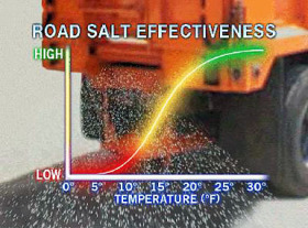 2. Low temperatures also diminish the effectiveness of road salt. Road salt is most effective when the surface temperature is 20-30 degrees. When the surface (the road) gets down to 15 degrees and below, the effectiveness of road salt falls off dramatically. Which means that when it's very cold, the roads will become snow-packed and treacherous more quickly, and the snow that accumulates cannot be cleared as easily. (Salters and plowers, correct me here if I am mistaken.)
Just a little background there to give you some context. Information: it's what Monsoon is all about!™
Expect snow to start around here by about 10 or 11pm, with the heaviest action falling after midnight.
Snow begins to taper by 8 or 9am and will end altogether by 10 or 11am Tuesday. And then skies will clear gradually throughout the day.
MY CALL:
Chance of delay Tuesday, 93%
Chance of cancellation Tuesday, 71%
 A publicity still from a 1988 German-made madcap comedy called Starke Zeiten (roughly, Groovy Times) that stars Hasselhoff as an American scientist who tries to dupe a Saudi Arabian dude, and has a monkey wearing human clothes. I have not seen this Zugunglück (train wreck), but I will not rest until I do.Overcast with scattered snow showers on Wednesday morning, possibly resulting in delays (but probably not cancellations).
And then Thursday looks fine. Ass-cold, but fine. High of only 12.
Friday morning will be like a recursion of this morning: the temperature will get down to -4, and the wind chills will approach -20. So a cold-weather delay on Friday looks like again.
The weekend looks nice, though! Shit, wait. Snow possible on Saturday and Sunday, with some sleet mixed in on Saturday night.
Stay tuned for updates!
 Monsoon Martin
I forgot to say what accumulations I expected. (Thank you to my favorite lawyer-turned-teacher, Alison Clark, for hipping me to that omission.)
Delaware, Maryland, South Jersey: 6-8 inches
Philadelphia, Chester, Lancaster, Delaware, and Montomgery Counties, as well as NYC: 4-6 inches
Berks: 3-5 inches (Note: this will likely be the cutoff area, so some in Berks may get 2 or 3 inches, but others may get 4 or 5. Unlike in most storms, accumulations will actually be higher in the south.)
Lehigh Valley, Schuylkill County, Poconos, North Jersey: 2-4 inches
 Post a Comment
 View Printer Friendly Version
 Email Article to Friend
Reader Comments