
Update on the Spike Lee-VE (Vernal Equinox) Storm.
First, it was brought to my attention that in recent years, former NBA star Mookie Blaylock went into a downward spiral that included alcoholism (that led to seizures), DUI arrests, and finally an accident in which Blaylock hit another driver head-on, killiing her. He's now in prison, having been convicted of reckless driving and vehicular homicide. So, you know, his nickname was cool, but this is some heavy stuff - and unsuitable for naming a pesky little late-season storm after.
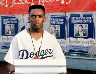 And so I hereby christen this storm the Spike Lee-VE Storm, for the filmmaker / agitator turns 59 on Sunday, if you can believe it. (Coincidentally, he played a character called Mookie in the film Do the Right Thing, but I think that character was named after Mets centerfielder Mookie Wilson.)
So all kinds of crazy talk is floating out there: we're getting 6-12 inches of snow, we're gonna have several days off of school, we're doomed, Donald Trump is going to be our next President.
None of this is going to happen.
Let me just tackle the weather bit for now.
Here's what to expect:
Light snow starts late Saturday night, right around midnight. Light snow showers overnight and into Sunday morning. This is a very wet snow - this fact, combined with the very warm surface temperatures and the lightness of the snowfall, will result in only a bit of accumulation on grassy areas and parked cars, but just wet roads and no travel headaches.
When the snow becomes steadier - I expect this to happen in the early to mid afternoon on Sunday - we could see a bit of accumulation on paved surfaces (roads and whatnot) and a bit more difficulty in travel. The snow tapers by 8 or 9pm and should be gone altogether by about 1am Monday.
Still, use caution on bridges and overpasses, and be on the lookout for slick spots developing overnight Sunday that could linger into Monday morning's commute.
Accumulations: an inch or two on grassy areas; an inch on roads.
School:
Chance of delay Monday, 14%
Chance of cancellation Monday, 1.77%
Monday turns out windy and chilly with a high in the low to mid 40s (but wind chills in the low 30s).
60s and 70s by the end of the week!
Monsoon
Vernal Equinox Snowstorm?!?!?!
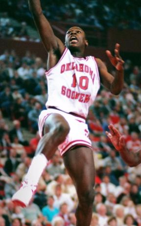 March 20th is the birthday of basketball great Daron Oshay "Mookie" Blaylock. The band Pearl Jam originally called themselves Mookie Blaylock, changing the name before released its first album, but naming the debut album (Ten) after Mookie's uniform number.Hi.
I really thought winter was over. Meteorological winter ended on February 29th. And the actual season of winter will end on Sunday night, March 20th.
It's the vernal equinox (from the Latin vernus, of the spring, and the Latin equi + noctium = equal night). And it may bring a consarned, flibberty-gibbeted, sum-bastardy snowstorm.
But it probably won't.
It's a Nor'easter - a coastal storm. In order for us to get accumulating, school-canceling, travel-snarling snow (given the sun angle, the surface warmth due to the mild recent temperatures, and all that), we'd have to get heavy snow for an extended period, and we'd have to get just the right shot of arctic air, and the track would have to be just right.
All of which could happen. I just don't think it's likely.
Right now I'd give us a 6% chance of this materializing into a snowstorm worth a good g.d.
Of course, you should stay tuned for updates!
Monsoon
The R. I. Pocock's Birthday Storm
 March 4th is the 153rd anniversary of the birth of British zoologist Reginald Innes (R. I.) Pocock, whose name definitely sounds like the punchline of a Bart Simpson prank call.
Anywho, this little storm is going to be our last real tangle with Old Man Winter.
What to expect:
Thursday 3/3 is sunny and cold, but with much calmer winds. High in the mid to upper 30s. Snow showers roll in starting around 10 or 11pm. Snow on and off throughout the night. Temperatures hold steady just below freezing, so most of the accumulation should be on grassy and unpaved surfaces. Still, watch for slippery roadways.
Friday 3/4 will begin with snow showers making the morning commute a bit hazardous; snow ends toward noon. There may be a lingering snow shower or two in the afternoon (or a flurry), but that's it. High in the upper 30s, low in the lower 20s.
Chance of delay Friday: 29%
Chance of cancellation Friday: 17%
Saturday 3/5 will be partly sunny, but clouding up toward evening. There could even be a snow shower or two on Saturday night. High in the mid 40s.
Sunday 3/6 looks overcast with temperatures rising toward 50.
Monday 3/7 (Wanda Sykes' birthday), upper 50s.
Tuesday 3/8 (Micky Dolenz' birthday), upper 60s!
Wednesday 3/9 (Emmanuel Lewis' birthday) and Thursday 3/10 (Chuck Norris' birthday), 70s!!
Then we get back to normal (highs in the 50s), but no more snow.
Monsoon
 Monsoon Martin
|
Monsoon Martin
|
 Post a Comment
|
Post a Comment
|
 1 Reference
|
1 Reference
|  Email
|
Email
|  Print
Print
Meteorological Winter ends Monday, but is that it?
Alright, so. Meteorological winter runs from the beginning of December through the end of February in the Northeast. But two models in particular (the Canadian and European weather models) have been suggesting that winter hasn't finished with us yet - maybe in a big way.
After springlike conditions today (highs in the low to mid 60s), Monday 2/29 will start out cloudy (there may even be a shower), but then the skies will clear. Breezy with a high near 60.
Partly sunny and still mild on Tuesday with highs near 60 once again. Since temperatures will only get down into the low 40s overnight, the precipitation we'll see Tuesday night into Wednesday morning will be plain rain (rather than any icy stuff).
Wednesday looks seasonably cooler and overcast with showers early. Highs in the mid 40s.
 David Hasselhoff as Garthe Knight.Thursday looks partly sunny with a shower or two early. Highs in the low 40s.
Friday, you're not even going to believe this. Snow. Several models are seeing snow. (Others are seeing dominant high pressure producing clear skies.) So stay tuned for updates on this one. I mean, I know I always say that, but it's going to be especially critical here.
Saturday, sunny with highs in the low 40s.
Sunday, more snow! (It will be overcast, but accumulating snowfall looks less likely here.)
And then next week - the week of Monday 3/7 - we'll see milder temperatures (50s and maybe even 60s) and a bit of rain here and there, but no snow.
And now you're caught up.
Monsoon
Monsoon Martin
|
Post a Comment
|
1 Reference
| Email
| Print
The Edward James Olmos' Birthday Storm
 Legendary stage and screen actor Edward James Olmos, best known for his roles as the stolid Lieutenant Martin Castillo on "Miami Vice" and as cal-KOO-lus teacher Jaime Escalante in 1988's Stand and Deliver, turns 69 on Wednesday 2/24. He's a really good actor and I have long admired his activism, especially around Chicano issues. So he deserves a storm, right?
There are all sorts of factors at play for the EJO B-Day Storm: sun angle, jet stream, extreme low pressure, and convective bloviation.
Confession: that last thing, I made up. (All the rest of them are real.)
Here's what to expect over the next 10 days or so:
Tonight: cloudy with a shower or two. No big. Temperatures falling from the 50s now to the 30s by morning commute.
Monday 2/22: clearing with highs in the upper 40s.
Tuesday 2/23: afternoon showers with a high in the lower 40s, then rain likely in the evening and overnight. Lows will be at or just above freezing, so we could see some travel issues for the Wednesday morning commute. (If the storm tracks farther east, we could see a bit more of an issue with snow and/or ice. But right now, it looks like all rain.)
Wednesday 2/24: rainy and breezy all day with temps in the mid to upper 40s. We will likely get an inch to an inch and one or two fifths on Wednesday, so pondiness and flooded roadways are something to watch out for.
Chance of delay Wednesday: 21%
Chance of cancellation Wednesday: 6%
Thursday 2/25: overcast, quite windy and drizzly. Highs in the upper 40s.
Friday 2/26: partly cloudy, but breezy and noticeably cooler. Highs in the upper 30s will feel like the upper 20s. Overnight lows in the low 20s will feel like the teens. So, colder.
Saturday 2/27 and Sunday 2/28: sunny with highs only in the low to mid 30s.
Leap Day: snow. For real. Right now it looks like the kind of event that would give us 2-4 inches, but that's way premature. Nah, I shouldn't have said that. Forget I said that.
 Lion Day: I call it that because March comes in like a lion and goes out like a lamb. And because March 1 is also the birthday of Winston Rodney, better known as Burning Spear, who took his stage name from Kenya's liberator and namesake, Jomo Kenyatta, who was a contemporary of Haile Selassie, who is a central figure of Rastafarianism, which considers him "the conquering lion of the tribe of Judah." So it all fits.
Anywho, the weather on 3/1 will be sunny and cold (high near freezing).
Future action: Anything else on the horizon? Maybe a little dusting on Thursday 3/3. Otherwise, nah.
Monsoon