
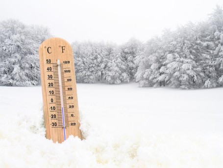
Weather ruminations and forecast update
Here's the thing about the weather, and I find it both maddening and exhilarating: it does what it wants.
There are 4-5 major forecast models (and myriad lesser ones) that rely on data and algorithms and trends to develop a forecast. It should be noted that these models rarely agree, which should be a clear signal that the weather almost seems to be actively resisting being accurately predicted. Like, you think you can forecast me? Well, watch this.
In more specific terms, even with all of our technological advances and measurement tools and whatnot, forecasting certain kinds of weather still feels like--at best--a notch or two above a coin flip.
Meteorologists have gotten pretty good at predicting temperatures, pretty good at reading the isobars and isotherms, shit like that. But when it comes to any kind of precipitation, forecasting is downright hapless. And with "hyperlocal" forecasting, which purports to be able to pinpoint the exact conditions you will encounter when you step outside the door, the accuracy seems to have gotten even less reliable.
How many times have you checked the weather on your phone and it says "it's raining, you're gonna get soaked, abandon hope," but you go outside and it's not doing shit? Birds singing, blue skies, dry pavement? Idyllic as you please.
Or it says that snow will begin in 17 minutes, but it actually began about an hour ago and already stopped, and never starts up again?

As it relates to the weekend storm, various weather outlets and meteorologists (and the forecast models that, to a large extent, drive them) will tell you exactly when it's supposed to start precipitating; when it's snow, or freezing rain, or plain rain, or sleet; when the roads will be slippery. But there's so much happening in the atmosphere during a storm that this certainty is laughable. 95% of those predictions will be wrong, and the other 5% got close because a broken clock is still right twice a day, which come to think of it, is one of those rare sayings that works with us old-heads (clocks with hands) and young-uns (digital jawns) alike.
One neighborhood will get 10 inches of snow while the next one over gets 4 inches. Hamburg gets mostly rain, but Shillington gets ice and snow. Shouldn't it be the other way around?
Last thing on this: there are so many layers to the atmosphere (each one is like its own ecosystem), and so many currents and streams in that atmosphere that move warm air and cold air and tepid air hither and thither, that it's a wonder any storm forecast is ever accurate. Because really, when it comes down to it, despite the GFS, the NAM, the Euro, Siri, Alexa, Google, and your mom--we have little understanding of why things happen.
So what are you saying, Monsoon? You're not going to even try to navigate us through this meteorological minefield? You're just throwing up your hands?

Alright, so here's the forecast and I'm going to do six zones, because that's the type of magnanimous and inclusive motherfucker I am:
Philadelphia and surrounding counties: snow starts around 1pm Saturday, accumulating an inch or two. By 6 or 7pm, snow mixing with, then changing over to, rain, which continues overnight. Sleet mixes in around 7-9am, then temperatures begin their plunge, so back to snow by 10-11am. Snow tapers by mid-afternoon and is finished by 4pm. Watch for flash freeze thereafter as temperatures quickly go from cold to balls-cold. Wind chills in the negative teens by Monday morning.
Worst travel times: Saturday afternoon, Sunday morning, and then Sunday evening through Tuesday morning (low temps, strong winds, ice).
Lehigh Valley and Berks: snow starts about 12-1pm Saturday, accumulating 2-3 inches. Snow mixes with sleet between 10pm and midnight; plain rain overnight (about 12-5), then freezing rain, sleet, and snow from 5-8, then snow from 8am-2pm Sunday. Total accumulations: 4-6 inches of snow and sleet. Watch for flash freeze thereafter as temperatures quickly go from cold to balls-cold. Wind chills in the negative teens by Monday morning.
Worst travel times: Saturday afternoon, Sunday morning, and then Sunday evening through Tuesday morning (low temps, strong winds, ice).
Lancaster, York, and Cumberland: Snow mixed with sleet and freezing rain straight away (1pm-midnight). Plain rain overnight. Maybe a bit of snow at the end (11am-1pm Sunday). Very little if any accumulation. Watch for flash freeze thereafter as temperatures quickly go from cold to balls-cold. Wind chills in the negative teens by Monday morning.
Worst travel times: Saturday afternoon and evening, and then Sunday evening through Tuesday morning (low temps, strong winds, ice).
North Jersey and NYC: Snow arrives 3-4pm Saturday. Snow mixes with sleet and freezing rain around midnight, then changes over to sleet and freezing rain. Expect 2-4 inches of snow and ice from this storm, as well as several days of travel paralysis. Oh! And power outages. A little snow mixed in on the "back end" (Sunday afternoon), but nothing that will add to storm totals appreciably. Watch for flash freeze thereafter as temperatures quickly go from cold to balls-cold. Wind chills in the negative teens by Monday morning.
Worst travel times: Saturday afternoon through Tuesday morning (low temps, very strong winds, ice, travel woes, stay inside).
South Jersey: this looks like an all-rain event for you lucky sons of bitches down the shore. Maybe a little snow mixed in on the "back end" (Sunday afternoon), but don't you dare complain about that. Watch for flash freeze thereafter as temperatures quickly go from cold to balls-cold. Wind chills in the negative single digits by Monday morning.
Worst travel times: maybe a little slipperiness on Sunday afternoon? Then Sunday evening through Tuesday morning (low temps, very strong winds, ice).
Bucks County and central Jersey / Princeton: rain and snow start by around noon Saturday. Becomes all snow after 5 or 6pm. Then mixes with sleet 9-10pm, then after midnight it's all rain. Changing to sleet and freezing rain by 5 or 6am, then maybe a bit of snow on Sunday afternoon. Total accumulation, 2-4 inches of sleet and snow. Pretty gross, sounds like. Watch for flash freeze thereafter as temperatures quickly go from cold to balls-cold. Wind chills in the negative teens by Monday morning.
Worst travel times: Saturday evening and overnight, Sunday morning, and then Sunday evening through Tuesday morning (low temps, strong winds, ice).
Stay tuned for updates!
 Monsoon Martin
 Post a Comment
 Email
Email Print
PrintTwo systems to discuss.
The first one, affecting the region overnight Thursday into Friday, is relatively weak and fast-moving, so impacts should be minor to moderate.
The second one, heading at us from Saturday afternoon to Sunday evening, has the potential to be significantly disruptive and messy. And it will usher in the coldest air of the season. By far.
But I'm getting ahead of myself.
Thursday will be partly cloudy with a high of 31. As clouds roll in, we could see an isolated snow shower or two as early as 5 or 6pm, but generally the snow will not begin in earnest until 8-9pm (Berks) and 9-10pm (Montgomery). Snow continues intermittently (and of varying intensity) until about 5-6am (Berks) and 6-7am (Montgomery). Storm totals: 1-2.75 inches (Berks) and .33-1.41 inches (Montgomery). Slippery conditions can develop quickly--even with just a coating of powdery snow--so be careful.
Classic two-hour delay scenario setting up for schools on Friday, so hey, there's that.
Alright, so the weekend.
There are a lot of "moving parts" to this system. It's not just a huge area of moisture that we can follow into the region, and there's a lot of instability throughout the atmosphere--and uncertainty regarding the precise track--that could have drastic ramifications in terms of amounts, precipitation types, and whatnot.
This is not to say that I cannot or will not give you a forecast. To refuse to do that would be wussy. And I may be a wuss when it comes to (and this is not an exhaustive list) sullying my hands or approaching a spider, I am most certainly not a wuss when it comes to forecasting.
Go big or go home, I always say. (Again, in almost every other scenario, I would absolutely go home. But not this one.)
Snow begins Saturday 12-1pm over the entire area. Expect some heavy snowfall rates Saturday afternoon and evening. There will be mixing (late evening and overnight) that may result in significant icing. Expect a period of freezing rain (rain that freezes onto the surface) on Sunday morning before changing back over to snow on the "back end" - Sunday between 12 and 6pm.
Right now, I'd say we should expect total snow accumulations of 8-10 inches in the Lehigh Valley and northern Berks, with higher amounts in Schuylkill County and the Poconos. Dunder Mifflin could see as much as 18-22 inches.
Southern Berks, Lancaster County, Montgomery County, whatnot: 6-8 inches with some ice thrown in for shits and giggles.
Philadelphia could see very minimal snow accumulations from this system: 2-4 inches at most. South Jersey and Delaware will likely see all or mostly rain.
Other selected predictions:
Princeton, 4-6 inches
Nutley, 8-12 inches
And then it gets so frickin' cold, you won't even believe it. Remember that part in The Day After Tomorrow when it gets so cold that everything goes limp and then freezes and then crumbles apart? Well, not that bad. But still.
 Note the savvy product placement from Wendy's.
Temperatures Sunday evening and overnight will plunge into the single digits (5 in Berks; 8 in Montgomery) and it will get very windy Sunday evening (15-20mph with gusts over 30), so wind chills will plunge to the negative teens by Monday morning. If school were in session on Monday, there would be at least a two-hour delay. But since it is an in-service day, teachers and staff will be expected to report at normal time. *shrugging person emoji that I can't figure out how to insert into this forecast*
High on Monday reaches 17 (Berks), 19 (Montgomery); still pretty windy. High on Tuesday reaches 27 (Berks), 29 (Montgomery); not nearly as windy.
Rest of the week: highs in the 30s.
Following weekend: cold as balls again. Highs in the low 20s; lows in the single digits.
Snow?
First of all, I want to wish my nephew a happy birthday. He's a year old today! Love ya, Griffin.

Anywho. The scuttlebutt is that there's some snow in the forecast this weekend.
I wondered where the term "scuttlebutt" came from, and thought it had to do with coal or fireplaces (for there is mention of a "coal scuttle" in Dickens' A Christmas Carol), but I was not quite correct.
The term, nautical in origin, actually refers to a cask or barrel (a butt) of drinking water kept on the deck of a ship; this vessel had a hole (or scuttle) in its lid so that sailors could access the water. Since the sailors often exchanged gossip whilst partaking in this fresh water, the term for a rumor became scuttlebutt.
So the scuttlebutt was literally the water cooler of the 19th century.
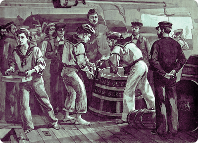 Sailors round the scuttlebutt, portrayed as far more staid and polite than they actually likely were.And for those who are now wondering what in Dickensian hell a "coal scuttle" is, it's a bucket or pail (a scuttle) which contains a modest supply of coal for feeding a coal-fired stove or heater.
This what happens when I decide to write a forecast: I cannot simply activate the prognosticational portion of my brain without activating all of it.
The weather.
It now looks pretty certain that the snow will stay to our south, giving us just a dusting.
The deets.
Light snow moves in about 8 or 9pm Saturday. Little or no accumulation, but remember that even a dusting can cause travel woes on untreated roadways. Maybe a snow shower or two overnight and early Sunday morning, ending by 5am and accumulating a coating to seven-eighths of an inch. Lingering light snow shower through the rest of Sunday morning, but no big.
Cold. (I mean, January. Expect that shit.) Saturday, Sunday, and Monday will see highs just at or below freezing (32) and lows in the upper teens or low 20s. Calm wind, though, which will make a significant difference.
Tuesday (pronunciation in Philly and immediate suburbs: TOOZ-dee) it'll get all the way up to 40. A frickin' heat wave.
Looking at a smaller system for Wednesday night into Thursday that could give us snow and/or freezing rain.
That's all.
The last time I will have to use the "s word" for at least 6 months
A little bit of snow overnight. Not a big deal but the timing could have a (fairly minimal) impact on the Tuesday morning commute.
Here's what to expect:
Rain showers develop by 9 or 10pm. Temperatures fall through the 30s overnight.
Rain will mix with (and briefly change to) wet snow between about midnight and 7am.
Chance of delay Tuesday, 12.43%
Chance of cancellation Tuesday, 0.31%
High on Tuesday will get into the lower 50s.
Wednesday - sunny and mid 50s.
Thursday - showers, high in the mid 60s.
Friday and Saturday - gorgeous!! Sunny with highs in the low to mid 70s. Showers on Sunday.
But at least it's not snow, am I right? Or am I right?

April 6th and 7th update
Hey there, gang.
So recent models have trended on a southward track - which means chances for accumulating, disruptive snow in our area have drastically decreased!
First, there will be some precipitation moving through tomorrow morning that may impact the morning commute.
Mixed light snow/sleet showers will be moving through between 4-8am, which could slickify roads in some areas. I don't expect widespread issues, but it's just something to keep in mind.
Chance of cancellation Friday, 4.51%
Chance of delay Friday, 8.11%
On Saturday morning, we'll just see light wet snow showers. Some areas could see as much as an inch, but generally we'll have a coating to a half-inch on grassy areas. I don't think it'll snow steadily enough to counteract the April sun angle and coat the roads.
So your plans for Saturday should be A-OK.
(To one reader in particular: your bloody hopes have come true. 😜)
Stay tuned for updates!