I'ma get right to it.
Potential for a big snowstorm.
Snow begins between 12-2pm Sunday. Heaviest snow is between about 6 and 11pm. Snow wraps up by 6-7am.
Here are more precise forecasts for some places:
Reading/Berks/Lehigh Valley/Lebanon Valley/North Jersey: 6-10 inches. Isolated areas will get a whole-ass foot. It will be heavy, wet snow, so shoveling is going to be particularly shitty. Schools are closed Monday, delay Tuesday. We may even see delays on Wednesday and Thursday, too, because it is going to be FRIGID. Overnight lows in the single digits. #shityanot
Montco/Bucks/Chester/Philly/Delco/central Jersey: 4-6 inches. The precipitation will most likely start as rain around noon, but change over to snow by late afternoon. We may even see some ice pellets (aka sleet) mix in during the heaviest period of precipitation (between 6pm and midnight). I still think schools are closed on Monday. Delays are on the table Tuesday, Wednesday, and Thursday as well.
South Jersey/Delaware/shorepoints: 1-3 inches at most, with the majority of the precipitation likely falling as rain. I don't think you'll see school closures in this area, but it's a remote possibility.
As I said, cold after the storm, and really cold and windy on Tuesday in particular. Yeah, screw you, Tuesday.
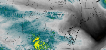 Never mind what all this is; just know that this image shows all the ingredients for a big-ass storm.Monsoon
 Monsoon Martin