Update from the dry slot!
So we got some snow.
10-12 inches in most places. 11 inches in Mount Penn, a foot in Bernville and Bowmansville, 13 inches in Reading, 13.5 in Mohnton.
A sampling of other totals from around the region: 14" in Wilmington, DE; 11-14" in north Jersey; 17" in Uwchlan Township, Chester County (site of the massive ice storm outages last week - those poor people); a foot in South Philly.
From the reports I have seen, roads aren't bad: plows have been able to do their work, most people have stayed home if possible, and there's been relatively little ice complicating matters. Secondary roads are gradually being plowed.
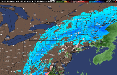
 Now we're in the "dry slot," which is an area of little or no precipitation that forms in a Nor'easter when it starts to pull away (to the northeast, hence the name). A still radar image from 3:45pm shows this. As you can see on the image, though, there's a whole mess of precipitation that's sitting off to our west. This is called the "back end," and it will deliver another 2-4 inches of "wraparound" snow in most places. Expect this action between about 6 and 10pm.
In addition, the winds will pick up this evening and overnight, which is bad in terms of the potential for downed limbs, power outages, and whatnot.
So the storm totals for Berks are going to end up in the range of 14-18 inches generally. Which is a lot.
Temperatures will be below freezing until about noon tomorrow, after which clouds will break and we'll get up to a breezy 38.
School predictions:
Chance of delay Friday, 100%
Chance of cancellation Friday, 70%
There's also another (comparatively) little storm that will move through early Saturday morning. I think this one will slide to our south, though. The most we'll see out of this storm (which is slated to hit between 2am and 9am Saturday) is about 1-3 inches. Saturday will turn out breezy and chilly (high 31) with plenty of afternoon sunshine.
Sunday is colder still. High 28, then getting down to 5 overnight.
Some ice is possible late Monday into Tuesday morning, so we could see a delay (but not likely a cancellation) out of that.
And then it warms up. Highs in the 40s on Tuesday 2/18 and Wednesday 2/19; highs in the 50s for the remainder of the week. I mean, the end of the week looks rainy, but I think that's not going to bother anyone. Just no more snow, you are saying. I hear you, I am typing.
A bit cooler the following week, but nothing else winter-weather-wise looms. I really believe that, and I really, really want that to be true. So it is both true (based on my forecasting) and my fondest wish.
To cheer you up, here is a video of a cat.
No cats were harmed in the making of this video.
Stay tuned for updates! And be sure to send me your snow totals, power outages, and road conditions!

Reader Comments